Assignment: VIIRS Nightlight Analysis
- Due Nov 8, 2021 at 11:59pm
- Points 50
- Questions 14
- Available after Aug 23, 2021 at 12am
- Time Limit None
Instructions
Nightlight data:
The Day/Night Band (DNB) detectors that are part of the Suomi-NPP Visible Infrared Imaging Radiometer Suite (VIIRS) are pioneering a new generation of satellite products that provide global measurement of nocturnal visible and near-infrared light that are suitable for Earth science and climate studies. The VIIRS DNB's ultra-sensitivity in low-light conditions has allowed for the generation of new science-quality nighttime products due to significantly improved resolution and calibration compared to those provided previously by the Defense Meteorological Satellite Program's (DMSP) generation of nighttime lights imagery. These improvements have allowed for better monitoring of both the magnitude and signature of nighttime phenomena and anthropogenic sources of light emissions.
Google Earth Engine provides stray-light corrected monthly composites of the VIIRS night light data. In this lab, we will use this data to investigate the image of the Iraqi Civil War and the rise of the Islamic State of Iraq and Syria (ISIS). The impact of ISIS is somewhat difficult to follow with coarser resolution satellite data. However, nightlight data can illuminate the humanitarian impact of this conflict with surprising detail.
From our reading, Li et al. (2018): The Iraqi Civil War (2014–2017) brought a severe humanitarian disaster to Northern Iraq, with more than 60,000 deaths and more than three million internally displaced persons. In January 2014, the Islamic State of Iraq and Syria (ISIS), which rapidly grew during the Syrian Civil War, seized Fallujah city in Al-Anbar Province. This operation was considered the first major success for ISIS in Iraq. After that, ISIS occupied a number of Northern Iraqi cities and towns, including Mosul and Tikrit, by June 2014. On 29 June 2014, ISIS announced the establishment of a new caliphate, named the Islamic State (IS), with Abu Bakr al-Baghdadi as its caliph. The ISIS was responsible for a great number of massacres (such as Sinjar Massacre of the Yezidi while in control.
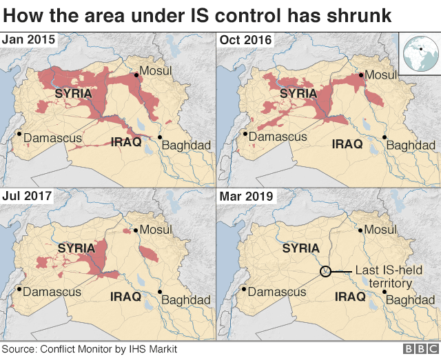

Reuters: IS was driven out of Raqqa, the de facto capital of its "caliphate", in October 2017
In this assignment we will use VIIRS nightlight data to investigate how the conflict affected the electrical system in the cities that ISIS occupied. And, since most of our data is available after 2014, how the electricity availability has recovered. We will investigate both spatial changes and time series.
After this assignment you should:
1) Be comfortable using and filtering feature collections available in Earth Engine.
2) Be able to filter and clip image data based on feature collections.
3) Interpret and visualize VIIRS nighttime data.